Nature
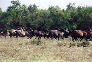
What’s absolutely great about the Greek landscape is the combination of mountain and sea, often tempered with astounding vegetation and flora. Pieria is one such amazing place which not only boasts the country’s highest mountain in Greece (Mount Olympus – or simply Olympos), as well as the country’s longest beach!
Adding to the richness of the Pieria region is the Olympus National Park and various wetlands (Agathoupoli, Nea Poroi, Kitros).
Olympus National Park
Olympus, the residence of the twelve ancient gods, was the first area which was declared as a National Park.
Mount Olympus is highest mountain in Greece and the second highest mountain in the Balkans. The terrain contains many charming and splendid features amongst which are sheer rocky peaks, deep gorges, alpine fields and thick forest all combining to create the rare magic of Mount Olympus. In total there are 52 peaks ranging from altitudes of 760 m to 2918 m which combined with the sheer ravines create scenes of unique beauty.
There are many streams on Olympus, but few are to be found at an altitude of over 1000 m.
The climate of Olympus is affected by its geographical location, size, strata and the exposure of the mountain slopes. Generally speaking it has a Mediterranean climate, warm and dry in the summer and wet in the winter. For approximately seven months of the year it is covered in snow (from November to May).
The average temperature in the winter ranges from -20o C to +10o C and in the summer from 0o C to 20o C, though this is not to say that there are not some exceptions that fall outside these ranges. Every 100 m up Mount Olympus the temperature drops by approximately half a degree. Thus if at sea level the temperature is 20o C at the same time on Mytikas Peak (2918 m) the temperature will be approximately 5o C.
The shape of Olympus, the polymorphous and changeable beauty of its nature, the fog covered peaks and law clouds bringing about frequent the under storms, filled people with awe and admiration from ancient times. There are recent archaeological finds that go back to the Iron Age. Prehistoric man chose to live at the foot of this glorious mountain. Inspired by its mystery he created the legends that gave birth to the Twelve Greek Gods.
The history of Olympus continued being turbulent even under the Turkish occupation. The mountain was used as a hiding place for the famous “armatol” fighting the “yoke of the tyrant”. During the German invasion in 1941, the Greek army along with Australian and New Zealand units fought important battles. Later on the Greek Resistance found a nestling place there.
The whole Olympus has been declared an archaeological and historical place in order to preserve its monumental and historical physiognomy.
source: http://www.olympusfd.gr/


Fotos: http://www.olympicnationalparks.com/photos-videos/

Alikes Kitrous
Aliki is a settlement of the municipality Pydna – Kolindrou in Pieria. The beach is sandy and is very near to Ancient Pydna. Aliki is often mentioned as a lagoon. Today the lagoon is a protected area.
H production of salt reaches 40,000 tons per year and lasts from March to October.
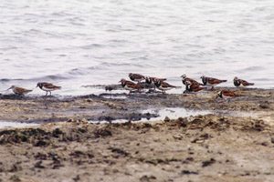
In the area near the salt marsh is a wetland of international importance, with rare birds.
Indicatively, in the lagoon we find the plant lily of the sea (Pancratium maritimum), specially adapted species and up to 1989 nest the rare Mediterranean Gull (Larus melanocephalus), whose number has now decreased significantly.
Salinas of Kitros are salt production facilities and are located on the beach of Kitros and ancient Atherada (where it was believed that there was the harbor of ancient Pydna). They are located 5 km east of Kitros. Their total area is about 10,000 hectares. The dunes are a special feature of the Lagoon of Kitros and is the largest area with such vegetation in Northern Greece.
Aliki holds the 5th position in GREECE in salt production.
Delta Aliakmona
The west coast of Thermaikos gulf extends one of the most important wetlands in Greece. Starting from Thessaloniki and going west, we find the lagoon Kalochori at the mouth of the French River Delta Axios estuary Loudias, the delta of Aliakmon and south Alyki Kitros.
The great variety of species of flora and fauna and the presence of rare species of birds led to international recognition of the value of the wetland. The area is one of the 11 wetlands of Greece International Importance under the Ramsar Convention. It is one of the Special Protection Areas of birds in Greece, based on the Directive 79/409 of the European Union. Also nominated for inclusion in the Network of Special Conservation Areas “Nature 2000” (NATURA 2000), EU Directive 92/43 on the Conservation of Natural Habitats and of Wild Fauna and Flora.
The current form of the wetland created over centuries under the constant interaction of natural phenomena (mixing fresh and salt water, accumulation of sediment of rivers materials) and human interventions.
The wetland area is not uniform in all its extent, consists of different habitats (habitats) with special features each. Regulatory role in these areas located between land and sea, playing the presence of water (surface, underground, permanent, seasonal) and the salinity. These elements affect the vegetation creating functional modules. So they have created societies with plants adapted to sand, plants resistant to salt, scrub trees, meadows with rushes, reeds, Waterplants and riparian arboreal vegetation.
More than 500 species and subspecies of flora in the area, creating diversity in colors during the year. Among them species that stand out for their rarity, and their spread is limited increasingly due mainly to human activities.


Pieria Mountain
The Pieria Mountains occupy the western side of Pieria. They are cut off from the mountainous massif of Olympus by Mount Titaros. Here one can find particularly scenic traditional villages. The peaks of the Pieria Mountains are frequently the end point for famous mountain routes. The Pieria Mountains have a good road network with country lanes, gravel and dirt tracks and mountaineering paths which are ideal not only for mountaineering per se but also for pleasant rambles in the picturesque environment. The road network is also ideal for outings by car.
The main peaks of the Pieria Mountains are Flambouro (2.197 m), Thoma Rachi (2.020 m), Sarakatsana (1.680 m), Saltapida (1.932 m) and Samari (2.002 m). Mountaineering activities are particularly well developed in Pieria. The Pieria Mountains have two mountain refuges.
The first is in the village of Ano Milia at an altitude of 1.000 m and the second in Sarakatsana at an altitude of 1.680 m. The route from Ano Milia to Flambouro passes through forests and along the banks of streams.
The route from Palea Vrya to Monacho Nero is particularly scenic, passing as it does via an ancient quarry.
Mountaineering path E4 crosses the Pieria Mountains and heads towards Olympus. The path passes next to Flambouro peak and the village of Ano Milia and descends to Kato Milia then continues on towards Olympus passing by Dion and reaching as far as Litochoro.
The Pieria Mountains are covered by forests of beech, oak, pine and fir while also playing home to a wealth of fauna.
Source: http://visitpieria.gr/